Find The Needle Add My Company
Herring Bridge (Third River Crossing), Great Yarmouth

Topographical & Underground Utility Detection Surveys

SJ Geomatics Ltd supported the delivery of Herring Bridge (also known as the Third River Crossing) — a landmark twin-leaf bascule bridge crossing the River Yare in Great Yarmouth. Acting as a key link between the strategic road network and the town’s port/enterprise areas, the scheme was designed to improve connectivity and help ease congestion on local routes.

Our role on the project was to deliver all topographical surveying and underground utility detection works, providing the accurate, decision-ready information needed to design, coordinate and construct in a highly constrained, safety-critical environment.


The project

Herring Bridge forms a new connection across the River Yare, linking the A47 at Harfrey’s Roundabout to the port and enterprise zone via South Denes Road. It is an opening bridge to maintain river access and navigation, and it became fully operational to road traffic in February 2024.


SJ Geomatics scope of services

We provided a complete, phased survey package to support design development, construction planning and safe delivery:

Topographical surveying

  • Establishment and verification of a robust site control network suitable for multi-discipline use across the works.
  • Detail topographical surveys covering highways tie-ins, approach corridors, compounds, hardstands, quay/river edges and adjacent assets.
  • Surface modelling to create dependable DTM/contour outputs for design and temporary works.
  • Survey updates delivered in step with programme requirements, including change capture as areas transitioned through enabling, civils and finishing works.

Underground utility detection (PAS 128-aligned approach)

  • Utility searches built around a structured workflow: records review, site reconnaissance, detection, mapping and reporting.
  • Use of complementary detection techniques (where applicable) such as:
    • Electromagnetic location (EML) and tracing for conductive services
    • Ground Penetrating Radar (GPR) to help identify non-conductive utilities and confirm routes
  • Clear depiction of utility routes, depths (where derived), and survey confidence to support safe excavations and reduce design clashes.


Key challenges

Delivering survey and detection on a complex marine/highways project demands more than “standard” site surveying. Key challenges on Herring Bridge included:

  • Live infrastructure and tight access: working close to active routes, temporary traffic management and changing site logistics.
  • Marine environment considerations: tidal influences, waterfront edges, temporary works and restricted work windows.
  • High interface risk: multiple contractors, plant movements and evolving exclusion zones requiring strong coordination.
  • Legacy/unknown utilities: utilities around established urban/port settings can be incomplete in records, increasing the importance of systematic detection and clear reporting.


Our approach

Accurate data that designers and site teams can trust

We focused on producing survey outputs that were immediately usable — not only geometrically accurate, but also clearly structured and consistent with the CAD/BIM and engineering standards used across the project team. Deliverables were issued with the right layering, symbology and metadata so that designers, temporary works engineers and construction teams could make confident decisions quickly.

Safety-first underground detection

Utility detection was planned around the real risks on site: avoiding service strikes, reducing abortive work and supporting safer excavations. Our reporting presented findings in a practical way for construction teams — clear mapping, unambiguous annotations, and information that could be briefed easily during planning and permit processes.

Responsive delivery across phases

As the works progressed, survey requirements changed. We provided a responsive service aligned to programme needs — supporting early feasibility and enabling works through to construction coordination and final checks.


Outcomes and value delivered

By delivering a complete package of topographical and underground detection surveys, SJ Geomatics helped the project team to:

  • De-risk design and construction through reliable ground truth information
  • Improve coordination between disciplines by working from a consistent survey baseline
  • Support safer excavation planning and reduce uncertainty around buried assets
  • Maintain progress by providing timely, programme-aligned survey updates in a challenging environment


Deliverables (typical outputs)

  • CAD topographical drawings (site control, detail, boundaries/constraints as agreed)
  • Digital Terrain Models (DTM), contours and surface outputs
  • PAS 128-style utility plans and reports (confidence/quality levels where applicable)
  • Mark-ups and issue registers to aid on-site briefings and design coordination


Want to de-risk your next infrastructure project?

  • If you’re delivering highways, bridges, ports or complex civils works, SJ Geomatics can provide the topographical and underground utility intelligence you need to plan and build with confidence.

    Get in touch to discuss survey scope, programme requirements and delivery across phased works.

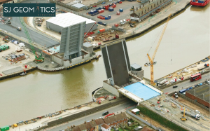
For more information on Herring Bridge (Third River Crossing), Great Yarmouth talk to SJ Geomatics

Enquire Now

  Please wait...

Location for : Listing Title